One thing that I've often wondered when I've seen a lake is: Is it a
"real" lake or is it a human made reservoir?
From the ground unless you already know, it's kind of hard to tell sometimes.
From the air and especially from Google Maps it gets much more obvious.
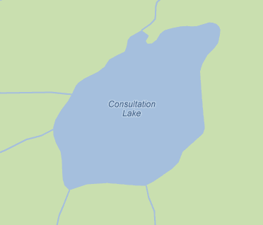
Natural lakes have rounded edges and look like they belong there. This is Consultation Lake in the Mt. Whitney area in the Sierra Nevada. Rivers enter and leave much the same way they came. This particular lake was covered in snow when its satellite photo was taken so this is the map view.
From the ground unless you already know, it's kind of hard to tell sometimes.
From the air and especially from Google Maps it gets much more obvious.
Natural lakes have rounded edges and look like they belong there. This is Consultation Lake in the Mt. Whitney area in the Sierra Nevada. Rivers enter and leave much the same way they came. This particular lake was covered in snow when its satellite photo was taken so this is the map view.
Lakes created by dams have that stopped up bathroom drain look about them

This is O.H. Ives Lake in East Texas that I have only seen from a plane.
The fastest way for me to tell from the air is to look for that tell-tale straight line which is the dam.
This are some local resevoirs near me. Briones and San Pablo:

Looking closer you can see the flat lines where the dams are located:


Another way to tell a fake lake is to look at where you see where a river should be.
In the O.H Ives Lake pictured above, you can see two rivers streaming in, but only a ghost of one on the other side and sure enough that is where the dam is, Zooming in on ghost river you can see a discontinuity that is the dam.

Another example is Red Bluff Resevoir:

Big River going in an just a trickle at the bottom. Zooming in you see:

Some are harder to spot but you can using the same technique.
This is Shasta Lake in California. It definitely has that plugged drain look about it.

There are several rivers so it takes some looking around to spot the affected river.
Looking on the West side there is a candidate on the bottom left:

And zooming in your see the dam:

But sometimes even natural lakes have human intervention.
Lake Tahoe is a gorgeous natural lake (http://en.wikipedia.org/wiki/Lake_Tahoe)

But even it has a dam where they can control the lake's level. I couldn't see it myself, but the Wiki page says it's in Tahoe City and on closer inspection in that area you can see it:

So now you have something to obsess over when you're looking out a plane window. Of course most people just enjoy the scenery or read a book.
3 comments:
How about Lake Champlain or Lake George?
Both Lake George, NY and Lake Champlain, VT are real lakes with some human intervention for flood control. I think is typical of the East Coast which has more lakes than the West.
Lake George:
http://www.lgpc.state.ny.us/faq.html
Q: How is the lake level managed if/when it is too high?
A: The lake level can be managed at an outlet dam (the "A Mill" dam) and a penstock (a pipe ten feet in diameter) located at the hydroelectric plant at the entrance of the LaChute River in Ticonderoga. The dam, built in 1903, is located about three-quarters of a mile beyond the natural rock dam at Ticonderoga. When the lake level of water is high the dam and penstock offer a means of discharging the excess water into the river and out of the Lake.
Lake Champlain's dam is more invasive and more of a hot topic.
Remove the Swanton Dam: Bring Back the Fish
http://www.mychamplain.net/news/lake-champlain-news/case-removing-swanton-dam-restoring-fish-passage
I LOVE having a window seat on a plane. I always regret not bringing a map so I can see where we are and what I am looking at below. Cool.
Post a Comment